You’ve decided you are going to hike the Appalachian Trail and now suddenly you’ve asked yourself: “How do I get there and back?” Fortunately for me, my family was willing to take me to Amicalola State Park to bid me farewell, and I also had a ride back from Baxter State Park after summiting Katahdin. Because not everyone has that luxury, I asked some of my fellow AT thru-hikers how they traveled to and from the trail, so that I could share some worthy options. Here they are!
Traveling to Amicalola Falls/Springer Mountain, Georgia
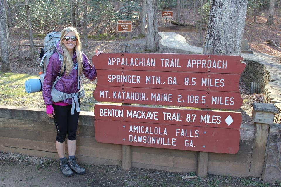
Standing at the beginning of the Approach Trail wondering what in the world I’ve gotten myself into.
Fly – This is obviously the fastest route. Everyone seems to freak out about flying due to not being able to carry fuel, but the AT is a well traveled pathway and local businesses have capitalized on that opportunity. There will be ways to buy fuel in town when you get there. You will likely have to check your pack due to trekking poles and knives being an issue in the cabin, so it may be best to mail those items ahead if you are wanting to carry-on your pack.
If you decide to fly, you will land at the Hartsfield–Jackson Atlanta International Airport in Atlanta, GA. From there you can choose one of several options:
- Get a shuttle directly to Amicalola Falls State Park from Atlanta (see below for shuttle services).
- Lodge at the Hiker Hostel in Dahlonega, GA and have them take you to the trail the following day. To get to the Hiker Hostel, you ride the MARTA (Metropolitan Atlanta Rapid Transit Authority) train which is located in the airport to the North Springs Station and a shuttle from the hostel will pick you up there. More info about the Hiker Hostel below.
Bus (Greyhound)/Train (Amtrak) – Riding in a bus or train will obviously take longer, but you won’t have to stress over checking a bag or deal with other concerns you may have with flying.
If you choose to ride Greyhound or Amtrak, your final destination will be Gainesville, GA. From there you can choose one of several options:
- Stay at the local Motel 6 across the street from the Greyhound Station (about 1.5 miles from the Amtrak Station) and/or shuttle directly to Amicalola Falls State Park.
- Lodge with Hiker Hostel who will pick you up from the Greyhound or Amtrak Station. More info about Hiker Hostel below.
Drive A Rental – If you’re up for a road trip, this option might be a little pricey (as one-way car rentals often are), but it will give you the most freedom during travel. You can arrange to drop the rental off at the airport and follow one of the options listed under flying (above) from there.
Shuttle Services from Atlanta/Gainesville Area:
- Survivor Dave’s Trail Shuttles
- Website: www.atsurvivordave.com
- No longer shuttles from the Amtrak or Greyhound Stations in Gainesville, GA
- Does have fuel for purchase
- Ron’s Appalachian Trail Shuttle
- Website: www.facebook.com/Rons-Appalachian-Trail-Shuttle-174270272614034
- Will shuttle from Atlanta, Gainesville, and other locations.
- Dogs welcome
- Fuel by request
- Uber – It seems this is an option from Atlanta or Gainesville, but I would try one of the shuttle services first.
Hiker Hostel in Dahlonega, GA
- Website: www.hikerhostel.com
- Offers a “Thru-Hiker Special” from February 24th-April 20th for $85 that includes:
- Shuttle from North Springs MARTA Station or Gainesville, GA to the Hostel
- Overnight stay in one of the bunk rooms
- Breakfast
- 8 oz of white gas or denatured alcohol (fuel canisters for sale)
- Shuttle to Amicalola Falls State Park or the Springer Mountain parking lot (0.9 miles north of Springer Mountain on USFS 42)
Traveling to Baxter State Park in Maine

Baxter State Park on a frigid October morning.
Fly – This is obviously the fastest route. Everyone seems to freak out about flying due to not being able to carry fuel, but the AT is a well traveled pathway and local businesses have capitalized on that opportunity. There will be ways to buy fuel in town when you get there. You will likely have to check your pack due to trekking poles and knives being an issue in the cabin, so it may be best to mail those items ahead if you are wanting to carry-on your pack.
If you decide to fly, you will land at the Bangor International Airport in Bangor, ME. From there you can choose one of several options:
- Get a direct shuttle from the Appalachian Trail Lodge and stay for a night in Millnocket (more info below). They will shuttle you to Baxter State Park the next day.
- Take the Cyr Bus Lines (website: www.cyrbustours.com) to Medway for $12 (which is much closer to the Appalachian Trail Lodge) and have them pick you up from Medway. This option is likely cheaper than a direct shuttle, but you can contact for pricing to confirm.
- Take the Cyr Bus Lines (website: www.cyrbustours.com) to Medway, lodge there, and have another shuttle service (see more options below) take you to Baxter State Park the next morning.
- Take the Cyr Bus Lines (website: www.cyrbustours.com) to Medway, and have another shuttle service (see more options below) take you to Millinocket and then Baxter State Park the next morning. Most hikers lodge in Millinocket.
Bus (Greyhound) – Riding in a bus will obviously take longer, but you won’t have to stress over checking a bag or deal with other concerns you may have with flying. If you choose to ride Greyhound, your final destination will also be in Bangor. From there you have the same options as listed above under flying.
Drive A Rental – If you’re up for a road trip, this option might be a little pricey (as one-way car rentals often are), but it will give you the most freedom during travel. You can arrange to drop the rental off at the airport in Bangor and follow one of the options listed under flying from there.
Shuttle Services from Medway/Millinocket Area:
- Maine Quest Adventures
- Website: www.mainequestadventures.com
- Can assist with buying fuel
- Has food drop services for the 100 Mile Wilderness
- Bull Moose Taxi
- Website: www.facebook.com/bullmoosetaxi/
Appalachian Trail Lodge in Millinocket, ME
- Website: www.appalachiantraillodge.com
- Shuttles to/from Bangor, Medway & Millinocket
- Gear Shop & Pack Shakedowns
- Cafe
- Lodging
- Food Drop Services in the 100 Mile Wilderness
Alternative Lodging in Medway & Millinocket
- Gateway Inn, 1963 Medway Rd, Medway, ME 04460
- Katahdin Cabins, 181 Medway Rd, Millinocket, ME 04462
- Katahdin Inn & Suites, 740 Central St, Millinocket, ME 04462
- 5 Lakes Lodge Bed & Breakfast, 45 Marina Drive, Millinocket, ME 04462
- Baxter Park Inn, 935 Central St, Millinocket, ME 04462
AWOL’s AT Guide
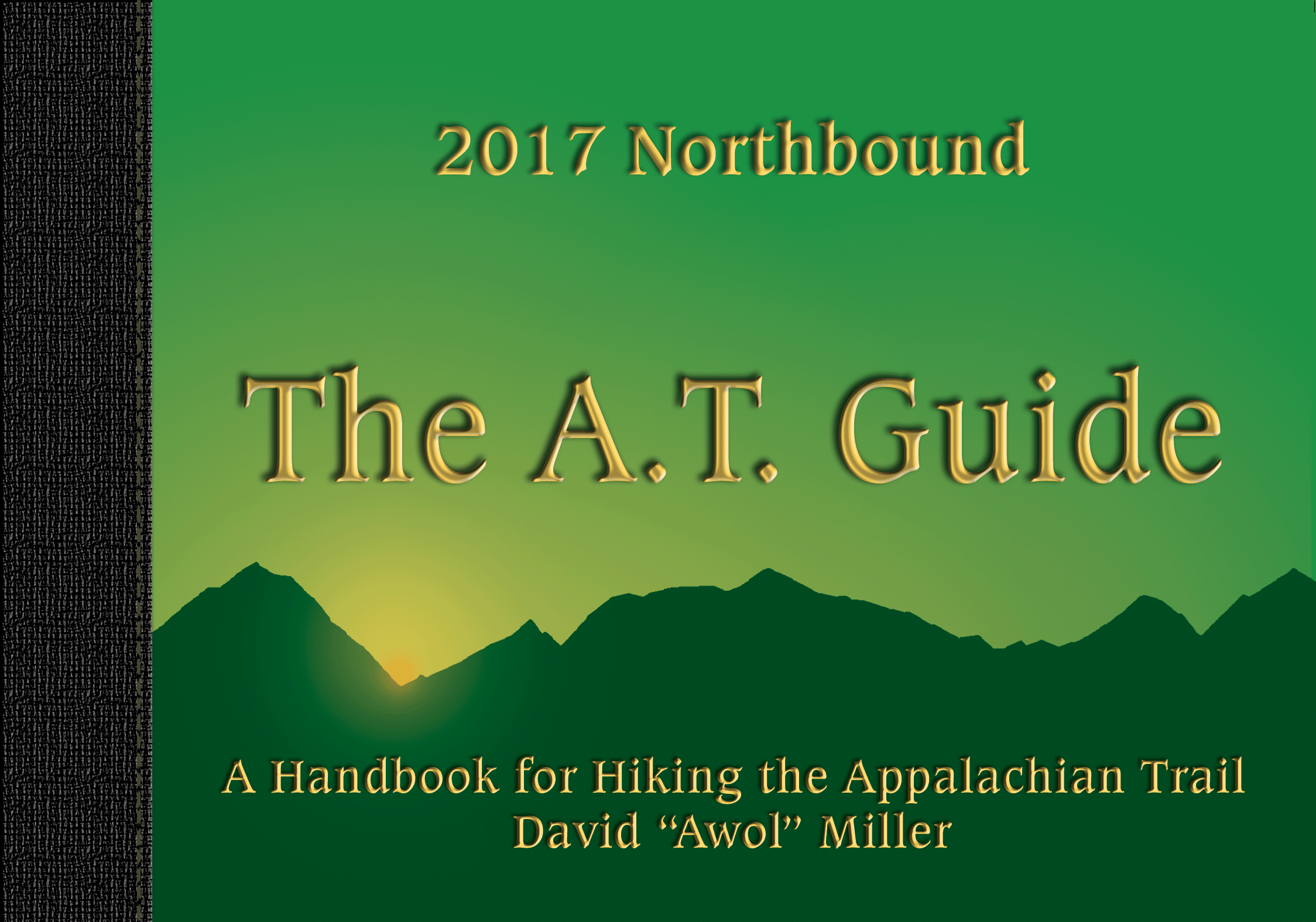
While I listed several options above, most of those are just what my fellow thru-hikers did and are by no means the ONLY options. The AT Guide includes valuable information for not only the northern and southern terminus, but also for accessing the trail (and parking) for all 2,000+ miles in between. This can be especially helpful for section hikers. For the most up-to-date information you can check the AT Guide for the current year: www.theatguide.com
Don’t Go Overboard With Planning
You never know what new adventures you might decide to embark upon once you meet new trail friends. Keep your options open!
I know you’re excited about setting your plans in stone for traveling to the trail, and making reservations ahead of time makes sense. With that said, I highly recommend you wait until you’re almost at the end of your journey before deciding how you will get home. Right now you have no idea how you will feel after one of the greatest adventures of your life or who you may meet along the way. While your current rat-race mindset may think you’ll want to rush home on a plane, your post-trail self may choose to ride a bus, road trip with your new friends, or even ride a bike across the country. Who knows! One of the beauties of the trail, though, is not knowing what it will bring. You’ll have time to figure it out, but the last thing you need is a deadline in your mind of when you MUST reach a certain point to hop on a plane and go home.
Well, I hope that was helpful! If you have traveled to Amicalola Falls State Park or Baxter State Park using one of these options (or especially another), please feel free to share details about how it worked for you so that others might learn from your experiences.
Happy Trails!
Dixie 🙂

Hi Dixie,
My wife and I did the approach trail last September and we used Richard Anderson as a shuttle ride to the top of Springer. His rates are very reasonable and we enjoyed the ride up the mountain.
W then hiked to down Amicalola.
His number is:
: r
(404) 408-2524
Great info–thank you!
My sister and I are hiking from Springer Mountain, GA October 20 to NC border. Is Richard Anderson’s shuttle service still available from Amicola to Springer? And can you tell me the cost? Thank you
I’m not sure, but through a google search I found his contact info. Hope this helps! Y’all have a wonderful time 🙂
Richard Anderson
706-276-2520 home – or – 404-408-2524 cell – or – richardjanderson@etcmail.com